


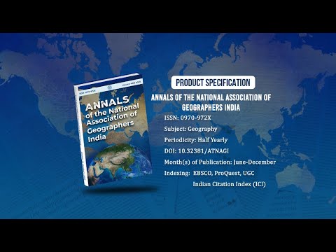
Annals of the National Association of Geographers India - A UGC-CARE Listed Journal
Published in Association with National Association of Geographers, India (NAGI)
Current Volume: 45 (2025 )
ISSN: 0970-972X
Periodicity: Half-Yearly
Month(s) of Publication: June & December
DOI: https://doi.org/10.32381/ATNAGI
Online Access is Free for All Life Member of NAGI
Urban Change Detection Using Remote Sensing and Geographical Information System — A Case Study of Delhi Region, India
By : Ashwani Kumar Awasthi , Umakant Rawat
Page No: 311-319
Abstract
Urbanization is one of the most widespread anthropogenic causes of the loss of arable land, habitat destruction, and the decline in natural vegetation cover. The present study is aimed at assessing the urbanization in Delhi over the period of 19 years (1992-2010) using remote sensing technology and spatial functionalities technique in Geographical Information System (GIS). Remote sensing data provide valuable and moreover spatio-temporal data on the processes and patterns of LULC change, and GIS is useful for mapping and analyzing these patterns. In this study I explore the temporal and spatial characteristics of urban expansion and LULC change of Delhi from 1992 to 2010.
Authors :
Ashwani Kumar Awasthi and Umakant Rawat
Research Scholar, Mahatma Gandhi Chitrakoot Gramodaya Vishwavidyalaya, Chitrakoot, Distt-Satna (M.P.)
DOI: https://doi.org/10.32381/ATNAGI.2019.39.02.10